While our new age devices can tell us where we are via WiFi triangulation (a la iPod Touch), 3G cell towers (a la iPhone) or GPS (a la Garmin), most aren't so great at knowing where we're looking when we're standing still. This is called "orientation" and it's probably not the number one feature people are looking for in a gadget, but it has interesting implications for the idea of placecasting.
Compasses, while terrible at holding address lists and taking blurry photos, have always had the orientation thing nailed. Standing still or on the go, this device has told mankind which direction he is facing...where to expect the sun, where to orient the temple, where to steer the ship or where to seek the stellar constellation.
That astronomical aspect is the point of a new Google program for Android-based devices that the folks at LatLong blogged about this week. Since new Andriod devices have a compass built in, they know not just where you're standing, but also what direction you're facing. From LatLong:
Once you have a phone with a compass ("magnetometer"), a plumbline ("accelerometer"), and you can pinpoint your position (using GPS) and your time (using a clock), that's enough to work out which direction you're pointing in the Universe.
SO, with a relatively small data file, this allows the program to show you the stars you should be seeing in the sky in front of you on this date at this time. This kind of technological convergence is really exciting, and the practical applications for the consumer will soon go far beyond stargazing.
Here's what it means for placecasting. The curious New York visitor, looking at New York Harbor at, say Castle Clinton will likely have questions about what she sees across the water. A device that knew her orientation could show her images like these (from GoogleEarth):
Sure, she knows that's the Statue of Liberty in the distance. But she probably doesn't know that's the Verrazano-Narrows Bridge in the distance behind it. A short podcast about it's relationship to the harbor in front of her would heighten her experience of the place. For that matter, a podcast about the statue of liberty could enhance the experience of the visitor who doesn't have time to catch the boat out there.
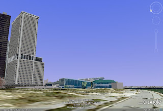
When she turns to the South East, here's what she'd see.
A tap on the low building in front would tell her its the Staten Island Ferry Terminal (South Ferry). Maybe it would even let her know how long a walk it would be to get there. Maybe it would tell her there's a coffee shop inside or which subway line runs there. A link to the ferry schedule would make sense, too.
If she cares about architecture, a tap on the building would let her know it's One New York Plaza , the southernmost skyscraper in Manhattan.
Turning back to the south, she'd see an island full of old buildings.
If the question is, "I wonder what all that is." A tap on the image on her device would let her know it's Governor's Island and link her to information about the place and a short overview podcast about it in relation to the harbor and the city. Maybe it even lets her know that she can download a more detailed audio walking tour of the Island if she wishes to go there and explore it firsthand.
Here's my point:
"What's that?" is not a question the Internet is very good at answering. But the combination of GPS/compass devices along with tagged photos and audio information should finally be able to make finding that answer almost as easy as asking it. Taking a tiny virtual world into the physical world should enhance real life, not distract from it.


No comments:
Post a Comment